
chevron_left
chevron_right
close
Out-of-Stock
MapEM – RF Drive Test System for EMF Mapping compliant with ITU-T K.113 | WAVECONTROL

MapEM RF drive test system for street-level EMF mapping. ITU-T K.113 compliant, 100 kHz to 90 GHz, ISO 17025 calibrated probes.
close
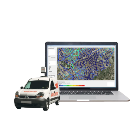
MapEM is a mobile system designed to create RF electromagnetic field level maps at street level. It consists of a MonitEM monitoring device and a dedicated mapping software, enabling large-area surveys such as cities. The system is compliant with ITU-T K.113.
- RF Exposure Drive Test for large urban areas
- Vehicle roof installation with magnetic base
- Electric field strength (V/m) measurement while driving
- Georeferenced data acquisition
- ISO 17025 accredited calibration
Key Advantages
- Comprehensive assessment of electromagnetic radiation at street level
- Year-on-year comparison to evaluate infrastructure changes
- Detection of sensitive points with high radiation levels
- Visual communication tool for public and authority reporting
- Plug & Play probes from 100 kHz to 90 GHz
Measurement Methods
- Isotropic RMS measurement
- Sampling rate: 1 measurement per second
- Recommended maximum speed: 50 km/h
- Memory: MicroSD (1 GB) + EEPROM
- Data export: Access, KML, CSV
- Map image export: JPG
Technical Specifications
- Sensor type: Isotropic, RMS
- Frequency range: depending on probe (100 kHz – 90 GHz)
- Interchangeable probe system
- Calibration: ISO 17025 accredited
- Power supply: 12 V DC (vehicle) + internal battery
- Data transfer: External USB connector
- Software: Windows compatible
- Dimensions: 70 × 40 × 8 cm
- Weight: 8 kg
- Protection rating: IP66
- Operating temperature: -25 °C to +60 °C
Compatible Field Probes
Compatible with E-field and H-field probes covering 100 kHz to 90 GHz. All probes are plug and play and supplied with individual ISO 17025 accredited calibration.
- WPF Series (E-field): 100 kHz – 90 GHz
- WPH Series (H-field): 300 kHz – 1 GHz
Typical Applications
- Urban EMF mapping
- Telecommunication infrastructure analysis
- Regulatory assessments
- Public transparency projects
- Infrastructure planning

Related articles
 High-Precision EMF Measurement for Standards-Compliant Exposure Assessment
Professional EMF measurement solutions compliant with ICNIRP, IEC and IEEE standards for automotive, industry and...
View full article
 Wavecontrol EMF Measurement Solutions for Personal Safety and RF Field Monitoring up to 90 GHz
Discover Wavecontrol solutions for precise EMF and RF field measurement and personal safety. Broadband measurement...
View full article
close